
Dennis Clark - amazing maps of imaginary worlds
It is hard to really understand the maps of Dennis Clark without seeing them in person. With a magnifying glass. Really, really close up. I had the great pleasure of meeting Dennis at the opening of the Rare Visions, Detour Art show, and was completely awestruck. A state worker in the accounting department in Topeka, Dennis has lived most of his life in Kansas.
He starts a map by closing his eyes, and placing down the pencil, he begins to draw the waterways. (Most early cities were started on bodies of water) Then he goes back and cleans up the lines and starts to build the city. The cities are always county seats and state capitols, and there is always a space for the courthouse, because they actually happen early after settlement. "I don't develop the capitol area 'til 20-30 years after first settlement because typically most states had one or two early capitols before establishing a final one."
Each drawing has a legend, complete with census of the city, and Dennis draws/builds the city much the way a city would grow and planned. For example, if a city is going to be in the upper Midwest it wouldn't have settled until the late 1830s-mid 1840s.
"At the left side of my design is a column with a key. I use that column for my "census", and to show how many aspects of civic life, i.e., schools, parks, etc., are present at any census year. For instance, if you see 1890, then very small notations such as 7s, 1 hs, 1 h, 12 p, plus a figure such as 50,225, the largest number means that the population was 50, 225 in 1890, and at that time there were 7 schools, 1 high school, 1 hospital, and 12 parks in the city.
As a basis for my counts, for each tiny 1/16 x 1/16 square, which represents a dwelling, I say there are five people living there. I really do count as I go along, so that the numbers at a given census are very close to accurate. Thus, I think the final census for Port Steven showed a population of approximately 386,000. That means there were very close to 77,200 of the little squares (dwellings).
Of course, as in a real census, it's not 100% accurate. I get phone calls, or nature calls, or I sneeze, or something else happens, and I lose count. However, I'm very certain that my count is at least 98% accurate when I finish a design."
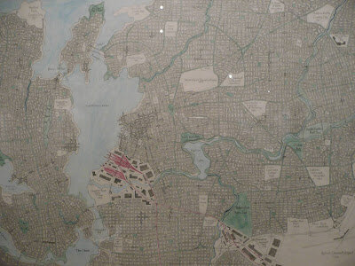
"I always show a school almost immediately after settlement because that happened everywhere in America. I don't put in high schools until about 1870-1880 because they weren't common 'til then. Hospitals generally wait 'til after the Civil War era, too.
I usually wait at least 10 years before I put in a college, too. Rarely were colleges and towns founded simultaneously.
Airports wait until the 1920's, and freeways wait until their era."
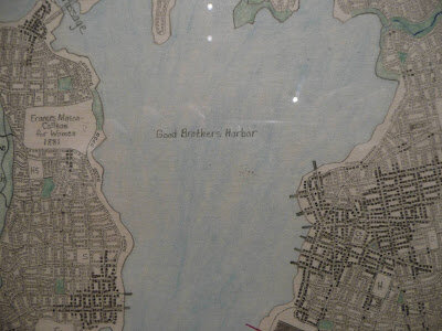
This specific map was created in honor of his brother, Steve, with a number of the places referring to important people and places in Steve's life.